Difference between revisions of "Munitions Constituents- TREECS™ Fate and Risk Modeling"
m (1 revision imported) |
m (1 revision imported) |
(No difference)
| |
Revision as of 15:57, 4 May 2018
The Training Range Environmental Evaluation and Characterization System (TREECS™) was developed for the Army to forecast the fate of, and risk from, munitions constituents (MC) such as high explosives (HE) and metals. TREECS™ is general enough that it can also be used for other types of contaminants and (non-Department of Defense (DoD)) sites. TREECS™ is validated as a valuable resource for predicting contaminant exposure in soil, groundwater, and surface water. This capability allows stakeholders to forecast exposure risks as well as evaluate various management alternatives and best management practices (BMPs) to avoid or reduce such risks.
Related Articles(s):
CONTRIBUTOR(S): Dr. Mark S. Dortch, PE, D.WRE and Dr. Billy E. Johnson
Key Resource(s):
- Field Demonstration and Validation of TREECS™ for the Risk Assessment of Contaminants on DoD Ranges[1]
- Field Demonstration and Validation of TREECS™ and Environmental Fate Simulator (EFS) for the Risk Assessment of Contaminants on DoD Ranges[2]
Introduction
There is a need to sustain training and firing ranges while complying with requirements to protect the environment from munitions constituents (MC) residue that can pose health concerns to human and ecological receptors outside of installations. Models are required for predicting the fate of MC so that environmental specialists can estimate if and when MC residue could pose a concern and to evaluate alternatives for managing MC exposure.
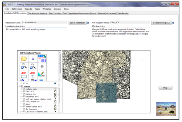
TREECS™ is a client-based modeling software system developed for personal computers. Figure 1 is a home screen shot of the software with application to Ft. Leonard Wood, MO. TREECS™ includes time-varying contaminant fate/transport models for soil, vadose zone, groundwater, and surface water to forecast MC (or other contaminants) export from ranges (or other source areas) and resulting exposure concentrations in each medium. TREECS™ is a system of numerical models that allows environmental specialists to readily assess migration of MC, as well as other contaminants, to determine if and when there could be risks to human and ecological receptors down-gradient of ranges and source areas. Additionally, TREECS™ can be used to evaluate best management practice (BMP) alternatives where concentrations presently exceed (or are predicted to exceed in the future) protective action limits (PALs) for human and ecological health.
A detailed description of TREECS™, as well as its performance exists[3]. Furthermore, its development is documented in a series of technical reports[4][5][6][7][8]. Development of associated BMP capabilities is also documented[9][10], as is a user’s guide[11].
Capability Levels
TREECS™ was developed with three levels of capability:
- Tier 1 consists of screening-level methods that assume conservative, steady state contaminant loading and fate. It requires minimal input data requirements and can be quickly applied by environmental specialists to assess the potential for contaminant migration into surface water and groundwater. If predicted surface or groundwater concentrations exceed PALs at receptor locations, then further evaluation with Tier 2 is recommended to obtain more definitive results.
- Tier 2 provides time-varying analyses and solves mass balance equations for both solid and water-dissolved phases. Additionally, MC or contaminant loadings to the soil or source area can vary from year-to-year based on site use. Media concentrations computed should be closer to those expected under actual conditions and lower than those computed with Tier 1 due to attenuation.
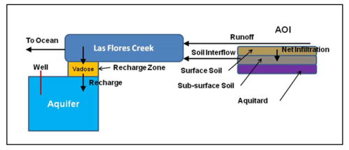
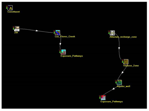
- Advanced Tier 2 is the third capability level. It uses a visual, object-oriented user interface for setting up more complex contaminant environmental media pathways, such as runoff to a surface water stream that recharges an aquifer, such as at Marine Base Camp Pendleton, CA[1]. The conceptual site model (CSM) and the Advanced Tier 2 setup for the Zulu Impact Area at Camp Pendleton are shown in Figures 2 and 3, respectively.


Additional Features
TREECS™ contains fate models for soil, vadose zone, groundwater, and surface water that can be connected in various manners to represent a variety of exposure pathways. The system and its models have graphical user interfaces (GUIs) for expediting model setup, and there is a Geographic Information System (GIS) to facilitate site applications and input development. BMP modules have been included for evaluating strategies to reduce or avoid future contaminant exposure and risk. There are three databases for providing physicochemical properties. Additionally, there is a health benchmark database to provide PALs based on recommendations by the Department of Defense (DoD) Range Munitions Use Subcommittee (RMUS), and there is a munitions database and MC residual mass loadings module for estimating MC loadings onto ranges based on types and number of munitions fired.
Applications
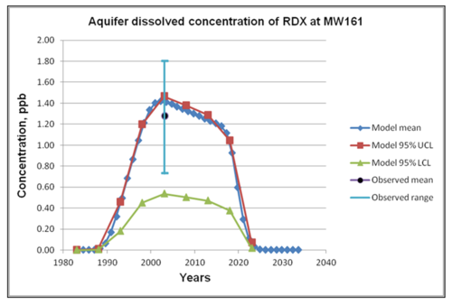
TREECS™ was initially validated for sites at Fort A. P. Hill (VA), U.S. Military Academy (West Point, NY), Ft. Jackson (SC), and Camp Edwards, Massachusetts Military Reservation (MMR)[12]. Additional validation work was performed[1] that included additional applications at West Point and MMR as well as Marine Base Camp Pendleton (CA). Example validation results for the high explosive RDX in groundwater at MMR are compared with observed RDX concentrations (Fig. 4). Model 95% confidence limits due to uncertainty of the RDX degradation rate are also shown.

Utility
It has been estimated that the use of TREECS™ as part of the Army’s Operational Range Assessment Program (ORAP) Phase II analyses can save the Army approximately three million dollars every five years[1]. However, the benefits of using TREECS™ may go far beyond these cost savings. Modeling can be used to forecast not only if, but when PALs will be exceeded. Additionally, the modeling system can be used to assess BMP strategies for avoiding future PAL exceedances and to evaluate the carrying capacity of existing and future training/firing ranges. Modeling can provide insight for improved sample design and monitoring. It also allows the assessment of “what if” scenarios without the risks and costs associated with trial-and-error field implementation. Moreover, TREECS™ usage can be an integral part of the successful administration of ORAP and related range sustainment programs, which avoid substantial amounts of money being lost if operational ranges are closed due to compliance failure. It was shown that TREECS™ could be rapidly applied (in < 80 labor hrs), using readily available data, and providing accurate results[1].
TREECS™ version 5 can be downloaded at the TREECS™ website. Version 6, which includes the BMP modules, will be available near the end of 2016.
References
- ^ 1.0 1.1 1.2 1.3 1.4 1.5 1.6 1.7 Dortch, M.S., and B.E. Johnson. 2016 Draft. Field demonstration and validation of TREECS™ and CTS for the risk assessment of contaminants on DoD ranges. ERDC/EL TR-16-xx, U.S. Army Engineer Research and Development Center, Vicksburg, MS.
- ^ ESTCP, 2014. Field Demonstration and Validation of the Training Range Environmental Evaluation and Characterization System (TREECS) and Environmental Fate Simulator (EFS) for the Risk Assessment of Contaminants on DoD Ranges. ER-201435. ER-201435
- ^ Dortch, M.S., Johnson, B.E. and Gerald, J.A., 2013. Modeling fate and transport of munitions constituents on firing ranges. Soil and Sediment Contamination: An International Journal, 22(6), 667-688. doi:10.1080/15320383.2013.756453
- ^ Dortch, M.S., J.A. Gerald, and B.E. Johnson. 2009. Methods for tier 1 modeling with the training range environmental evaluation and characterization system. ERDC/EL TR-09-11, U.S. Army Engineer Research and Development Center, Vicksburg, MS. Report pdf
- ^ Dortch, M.S., B.E. Johnson, Z. Zhang, and J.A. Gerald. 2011. Methods for Tier 2 modeling within the training range environmental evaluation and characterization system (TREECS™). ERDC/EL TR-11-2, U.S. Army Engineer Research and Development Center, Vicksburg, MS. Report pdf
- ^ Dortch, M.S., B.E. Johnson, and J.A. Gerald. 2012. Extension of capabilities for the tier 1 and tier 2 approaches within the training range environmental evaluation and characterization system (TREECS™). ERDC/EL TR-12-11, U.S. Army Engineer Research and Development Center, Vicksburg, MS. Report pdf
- ^ Johnson, B.E. and Dortch, M.S., 2014. Hydrology Model Formulation within the Training Range Environmental Evaluation and Characterization System (TREECS) (No. ERDC/EL-TR-14-2). Engineer Research and Development Center, Vicksburg, MS Environmental Lab. Report pdf
- ^ Dortch, M.S., 2014. Evaluation of time-varying hydrology within the training range environmental evaluation and characterization system (TREECS TM) (No. ERDC/EL-CR-14-3). Engineer Research and Development Center, Vicksburg, MS Environmental Lab. Report pdf
- ^ Dortch, M.S., B.E. Johnson, and J.A. Gerald. 2013. Modeling firing range best management practices with TREECS™. ERDC/EL TR-13-6, U.S. Army Engineer Research and Development Center, Vicksburg, MS. Report pdf
- ^ Dortch, M.S. and Gerald, J.A., 2015. Modules for modeling firing range best management practices within TREECS™ (No. ERDC/EL-TR-15-7). Engineer Research and Development Center Vicksburg MS Environmental Lab. Report pdf
- ^ Gerald, J.A., B.E. Johnson, and M.S. Dortch. 2012. User guide for applying the Training Range Environmental Evaluation and Characterization System (TREECS™). ERDC/EL TR-12-16, U.S. Army Engineer Research and Development Center, Vicksburg, MS. Report pdf
- ^ Dortch, M.S. 2012. Validation of the training range environmental evaluation and characterization system (TREECS™). ERDC/EL TR-12-3, U.S. Army Engineer Research and Development Center, Vicksburg, MS.
